mojojojo
NAXJA Forum User
- Location
- Gresham, Oregon
We might be breaking trail to camp Thursday night. :firedevil
Bring it !!! :guitar:
We might be breaking trail to camp Thursday night. :firedevil
I wanna go soooo bad but i've only got about 20% tread on my front two. You guys think thats enough for any wheelin?
My tires are about 20% aswell..You can see pics of my front left tire if you look at my post in "What did you do to you xj today" from today.
Tread is required to "Throw mud"F"%$ it. I'm still goin' . hell if i cant go up any trails maybe i can just throw mudd everywhere and look cool
")
The big thing to worry about is having good tow points front and back. I don't know what to expect for conditions, so the big thing is just being prepared.I wanna go soooo bad but i've only got about 20% tread on my front two. You guys think thats enough for any wheelin?
:huh:Out!
Better hurry up.Ill get some detailed directions posted soon, if Dustin Doesnt beat me to it...

Basically after stopping for your Oregon ORV permit at the Gales Creek Shell (ask for a map), continue up highway 6 for approximately 7 miles. When you get to the top of the pass there will be signs for Rogers Camp/Browns Camp. Turn left at the summit following the signs. Take a right at the Y, and continue on Beaver Dam Rd. The road will split two more times and you'll still want to stay to the right. After you go over a small bridge, stay on the main road for a few miles, and follow the signs to Horse Camp.Stagecoach Horse Camp is easily reached by turning south off of Highway 6 at milepost 33 onto Beaver Dam Road and following the signs for 5 miles into the campground. It is home to camping and day use staging for accessing the Historic Hiking Trail Loop. Please note, Stagecoach sits in the heart of the Browns Camp OHV Trail area.
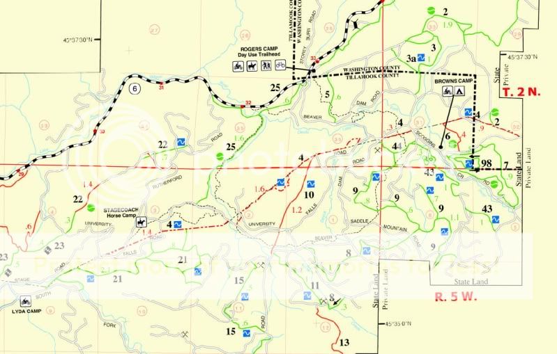
I reccommend Rutherford Road as the absolute quickest route for everyone !
However, if there is any ice / snow on the road i would not try this alone. This road is VERY steep and curvy !
My friend is coming up friday after work around 4-5. He will be in a red Durango and knows the way to camp.
Ill get some detailed directions posted soon, if Dustin Doesnt beat me to it...
Correct.so that was a lot of information at once. i will be towing my jeep up friday morning. am i heading straight for the horse camp from milepost 33? is that where everyone will be?