Victoria, British Columbia
From Wikipedia, the free encyclopedia
Jump to:
navigation,
search
This article refers to the city of Victoria. Information on Greater Victoria can be found in the Greater Victoria article. For electoral districts with the name Victoria, or in the area of greater Victoria, please see Victoria (electoral districts) Victoria
British Columbia Legislative Buildings in Victoria
Location of Victoria within the
Capital Regional District in British Columbia, Canada
Area 633 km²
Population 335,000
Pop'n density 529.2 /km²
Location 48°25′N 123°21′W Altitude 23
metres Incorporation 1849
Province British Columbia Regional District Capital Members of Parliament Denise Savoie Members of the Legislative Assembly Carole James,
Rob Fleming Mayor Alan Lowe
(
past mayors)
Governing Body Victoria City Council Time zone PST (
UTC-8)
Postal code V0S, V8N-V8Z, V9A-V9E
Area Code +1-250
Victoria.BC.ca Victoria is a
Canadian city, and the
provincial capital of
British Columbia. It is also the seat of the
Capital Regional District. Victoria is located on the southern tip of
Vancouver Island and is a global tourist destination. Its other main industries are government, the technology sector and the Canadian Navy.
Contents
[hide]
//
[
edit]
Location and population
Located on the southeastern tip of
Vancouver Island, overlooking the
Strait of Juan de Fuca, the City of Victoria has a population of approximately 74,100, and is the thirteenth most populous municipality in the province. The
metropolitan area comprising thirteen municipalities informally referred to as
Greater Victoria has a population of more than 335,000 and is the largest urban area on Vancouver Island.
[1]. It also currently ranks as the 14th largest
metropolitan area in Canada.
The city's chief industries are tourism, provincial government administration, and the technology sector. Other major employers include the
Canadian Forces (the Township of
Esquimalt is the home of the Pacific headquarters of the
Canadian Forces Maritime Command), and the
University of Victoria (located in the municipalities of
Oak Bay and
Saanich).
The city of Greater Victoria is the southernmost urban area in Western
Canada, located below the northern
49th parallel, which bisects Vancouver Island at the community of
Ladysmith, British Columbia.
[
edit]
History
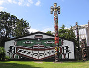
 Wawadit'la
, also known as Mungo Martin House, a Kwakwaka'wakw "big house", with
heraldic pole. Built by Chief Mungo Martin in 1953. Located at
Thunderbird Park in
Victoria, British Columbia.
[1]
Prior to the arrival of the Europeans in the late 1700s, the Victoria area was home to several communities of
Coast Salish peoples, including the Songish (Songhees). The Spanish and British took up the exploration of the northwest coast of North America beginning with the voyage of Captain
James Cook in 1776, although the Victoria area of the Strait of Juan de Fuca was not penetrated until 1791. Spanish sailors visited
Esquimalt harbour (within the modern Capital Regional District) in 1790 and again in 1792. Founded by the
Hudson's Bay Company in 1843 as
Fort Camosun (after the "camosack", a type of wild
lily native to southern Vancouver Island) as a
fur trading post, the settlement was later called
Fort Victoria, in honour of
Queen Victoria [2]. The Songhees established a village across the harbour from the fort. The Songhees' village was later moved north of
Esquimalt. When the crown
Colony of Vancouver Island was established in 1849, a town was laid out on the site and made the capital of the colony. The
Chief Factor of the fort,
James Douglas was made governor of the colony, and would be the leading figure in the early development of the city until his retirement in 1864.
With the discovery of
gold on the British Columbia mainland in 1858, Victoria became the port, supply base, and outfitting centre for miners on their way to the
Fraser Canyon gold fields, mushrooming from a population of 300 to over 5000 literally within a few days. In 1866 when the island was politically united with the mainland, Victoria remained the capital of the new
united colony and became the provincial capital when British Columbia joined the
Canadian Confederation in 1871. Victoria was incorporated as a city in 1862. In 1865
Esquimalt was made the North Pacific home of the
Royal Navy, and remains Canada's west coast naval base.
In 1886, with the completion of the
Canadian Pacific Railway terminus on
Burrard Inlet, Victoria's position as the commercial centre of British Columbia was irrevocably lost to the City of
Vancouver. The city subsequently began cultivating an image of genteel civility within its natural setting, an image aided by the impressions of visitors such as
Rudyard Kipling, the opening of the popular
Butchart Gardens in 1904 and the construction of the
Empress Hotel by the
Canadian Pacific Railway in 1908. Sir
Robert Dunsmuir, a leading industrialist whose interests included coal mines and a railway on Vancouver Island, constructed
Craigdarroch Castle in the Rockland area, near the official residence of the province's lieutenant-governor. His son
James Dunsmuir became premier and subsequently lieutenant-governor of the province and built his own grand residence at Hatley Park (used for several decades as a military college, now
Royal Roads University) in the present City of
Colwood.
A real estate and development boom ended just before World War I, leaving Victoria with a large stock of Edwardian public, commercial and residential structures that have greatly contributed to the City's character. A number of municipalities surrounding Victoria were incorporated during this period, including the Township of Esquimalt, the District of
Oak Bay, and several municipalities on the Saanich peninsula. Since World War II the Victoria area has seen relatively steady growth, becoming home to two major universities. Since the 1980s the western suburbs have been incorporated as new municipalities, such as Colwood and Langford. The thirteen municipal governments within the Capital Regional District afford the residents a great deal of local autonomy, although there are periodic calls for amalgamation.
[
edit]
Climate

Victoria's Inner Harbour with The Empress hotel in the background.
Victoria has a sub-Mediterranean climate
[3][4], with mild, damp winters and cool to warm, dry summers. Daily temperatures rise above 30°C (86°F) on an average of one or two days per year and fall below -5°C (23°F) on an average of only 2 nights per year. During the winter, the average daily high and low temperatures are 8.2°C (47°F) and 3.6°C (38°F), respectively. The summer months are equally mild, with an average high temperature of 19.6°C (67°F) and low of 11.3°C (52°F). Victoria does occasionally experience more extreme temperatures. The highest temperature ever recorded in Victoria was 35.3°C (96°F) on July 23, 2004, while the coldest temperature on record was -15.6°C (4°F) on December 29, 1968. Victoria has not recorded a temperature below -10°C (14°F) since 1990.
Thanks to the
rain shadow effect of the nearby
Olympic Mountains in Washington State, Victoria is the driest location on British Columbia's coasts, experiencing much lower rainfall than other nearby areas. Total annual precipitation is just 608mm (24in) at the Gonzales weather station in Victoria, contrasted to nearby
Seattle, (137 km/85 miles away to the southeast), with 970mm (38in) of rainfall, or
Vancouver, 100 km away, with 1,219 mm (48in) of rainfall. Perhaps even more dramatic is the difference in rainfalls on Vancouver Island.
Port Renfrew, just 80 km from Victoria on the wet southwest coast of Vancouver Island receives 3,671mm (145in). Even the Victoria Airport, 25 km north of the city, receives about 45% more precipitation than the city proper. One of the most striking features of Victoria's climate is the distinct dry and rainy seasons. Nearly two thirds of the annual precipitation falls during the four wettest months, November to February. Precipitation in December, the wettest month (109mm/4in) is nearly eight times as high as in July, the driest month (14mm/.5in). During the summer months, Victoria is the driest major city in Canada.
Victoria averages just 26cm (10in) of snow annually. Every few decades, Victoria receives very large snowfalls, including the more than 100cm (39in) of snow that fell in December 1996. On the other hand, roughly one third of winters will see virtually no snow, with less than 5cm (2in) falling during the entire season. When snow does fall, it rarely lasts long on the ground. Victoria averages just 2-3 days per year with at least 5cm (2in) of snow on the ground.
The rainshadow effect also means that Victoria gets more sunshine than surrounding areas. With 2,223 hours of sun annually, Victoria is one of the sunniest places in British Columbia, and gets more sunshine than most other cities in Canada except those in the southern Prairies. The benefits of Victoria's climate are evident through the city's gardens, which are more likely to display drought-tolerant oak trees, eucalyptus, arbutus, and even bananas, than they are likely to feature evergreen conifers, which are often associated with the coastal Pacific Northwest environment.
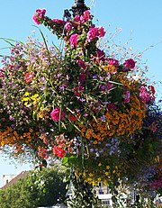
Colourful flowers bedeck the genteel "Garden City" downtown
Jan Feb Mar Apr May Jun Jul Aug Sep Oct Nov Dec Year Average daily maximum °C 7.0 8.6 10.6 13.1 15.9 17.9 19.8 20.1 18.5 13.8 9.4 7.1 13.5 Average daily minimum °C 3.0 3.7 4.5 6.0 8.2 10.0 11.3 11.7 10.7 7.9 5.0 3.2 7.1
Average precipitation mm 94.3 71.7 46.5 28.5 25.8 20.7 14.0 19.7 27.4 51.2 98.9 108.9 607.6 Average total snow cm 9.7 3.5 1.1 0 0 0 0 0 0 0 4.1 7.8 26.3 Average Sunshine h 78 102 150 205 267 271 331 303 222 148 81 65 2223 Data
[5]
Victoria's equable climate has also added to its reputation as the "City of Gardens" . With its mild temperatures and plentiful sunshine, Victoria boasts gardens that are home to many plant species rarely found elsewhere in Canada. Several species of palms, eucalyptus, and even certain varieties of bananas can be seen growing throughout the area's gardens. The city takes pride in the many flowers that bloom during the winter and early spring, including crocuses, daffodils, early-blooming rhododendrons, cherry and plum trees. Every Februrary there is an annual "flower count" in what for the rest of the country and most of the province is still the dead of winter.
Due to its Mediterranean-type climate, southeastern Vancouver Island is also home to many rare native plants found nowhere else in Canada, including
Quercus garryana (
Garry oak),
Arctostaphylos columbiana (Hairy
manzanita), and Canada's only broadleaf evergreen tree,
Arbutus menziesii (
Pacific madrone). Many of these endangered species exist here at the northern end of their range, and are found as far south as Central and Southern California, and even parts of Mexico.
[
edit]
Physiography and Soils
The landscape of Victoria was molded by water in various forms.
Pleistocene glaciation put the area under a thick ice cover, the weight of which depressed the land below present sea level. These glaciers also deposited stony sandy loam
till. As they retreated, their meltwater left thick deposits of
sand and
gravel. Marine
clay settled on what would later become dry land. Post-glacial rebound, which is still in progress, let the present-day terrain be exposed to air, with beach sand and gravel deposits in many places. The resulting soils are highly variable in texture, and abrupt textural changes are common. In general, clays are most likely to be encountered in the northern part of town and in depressions. The southern part has coarse-textured subsoils and loamy topsoils. Sandy loams and loamy sands are common in the eastern part adjoining
Oak Bay. Victoria's soils are relatively unleached and less acidic than soils elsewhere on the British Columbia coast. Their thick dark topsoils denoted a high level of fertility which made them valuable for farming until urbanization took over.
[
edit]
Neighbourhoods of Victoria
The following is a list of neighbourhoods in the City of Victoria. For a list of neighbourhoods in other area municipalities, see
Greater Victoria, or the individual entries for those municipalities.
[
edit]
Other facts
Victoria, British Columbia.
British Columbia Parliament Buildings in Victoria.
Victoria's skyline in May 2006.

One of the stone lions that guards the gate of Chinatown in Victoria.
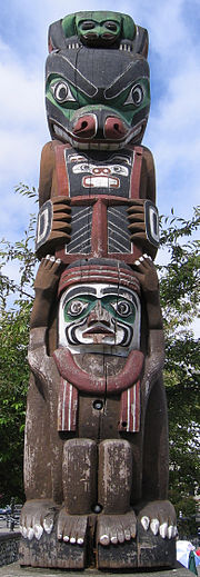
Totem pole on the inner harbour.
According to Statistics Canada, Victoria's crime rate in 1999 was the second highest in the country (11,865 crimes per 100,000 population). By 2002, Victoria was ranked fifth for overall crime (10,146 crimes per 100,000 population). These figures, however, represent the skewing effect of considering crimes committed in "downtown" Victoria in relation only to the "downtown" population. The Greater Victoria area comprises 13 separate municipalities (total pop. 335,000
CMA). The City of Victoria (pop. 74,100) acts as "downtown" for all of the outlying municipalities, hence the counter-intuitive and inflated crime figures.
The oldest (and most intact)
Chinatown in Canada is located within Victoria. In the heart of downtown are the
Parliament Buildings, the
Fairmont Empress Hotel and the acclaimed
Royal British Columbia Museum, with large exhibits on local
Aboriginal peoples,
Natural History and
Modern History. In addition, the heart of downtown also has the
Royal London Wax Museum,
Victoria Bug Zoo, and the
Pacific Undersea Gardens, which showcases the
Giant Pacific Octopus, the
Wolf Eel and other marine life of British Columbia. North of the city on the Saanich Peninsula are the
Butchart Gardens, one of the biggest tourist attractions on the island, as well as the
Dominion Astrophysical Observatory,
Victoria Butterfly Gardens and
Centre of the Universe planetarium
[6]. There are also numerous
National Historic Sites, such as the
Fisgard Lighthouse,
Craigflower Manor and Schoolhouse, Hatley Castle and
Hatley Park and
Fort Rodd Hill, which is a coastal artillery fort built in the late 1890s, located west of the city in Colwood. Also located west of the city you will find
Western Speedway, a 4/10th-mile oval and the largest in Western Canada.
Beacon Hill Park is the city's main urban green space. Its area of 620 square kilometres lie along Victoria's southern shore, and includes numerous playing fields, manicured gardens, exotic species of plants and animals such as wild peacocks, and a petting zoo. The park also includes a few areas of natural
Garry oak meadow habitat, an increasingly scarce ecosystem that once dominated the region. Each summer, Beacon Hill Park plays host to several outdoor concerts, and the popular Luminara Community Lantern Festival.
The
Victoria Symphony, led by
Tania Miller performs at the
Royal Theatre and the Farquhar Auditorium of the University of Victoria from September to May. Every BC Day weekend, the Symphony mounts "
Symphony Splash", a popular outdoor event that includs a performance by the orchestra sitting on a barge in Victoria's Inner Harbour. Streets in the local area are closed, as each year approximately 40,000 people attend a variety of concerts and events throughout the day. The event culminates with the Symphony's evening concert, with Tchaikovsky's 1812 Overture as the grand finale, replete with cannon-fire, a pealing carillon and a fireworks display to honour BC Day.
The only Canadian Forces Primary Reserve brass/reed band on
Vancouver Island is located in Victoria. The
5th (British Columbia) Field Regiment, Royal Canadian Artillery Band traces its roots back to 1864, making it the oldest, continually-operational military band west of Thunder Bay, Ontario. Its mandate is to support the island's military community by performing at military dinners, parades and ceremonies, and other events. The band performs weekly in August at Fort Rodd Hill National Historic Site where the Regiment started manning the guns of the fort in 1896, and also performs every year at the Cameron Bandshell at Beacon Hill Park.
Victoria can be reached by air and ferry. The
Victoria International Airport has non-stop flights to and from Toronto, Honolulu (winter), Salt Lake City, Seattle and many cities throughout Western Canada. Multiple scheduled helicopter and seaplane flights are avaialble daily between Victoria harbour and
Vancouver International Airport or Vancouver harbour (35 minute flights). The
BC Ferries Swartz Bay Ferry Terminal, located 29 kilometers north of Victoria, is a bustling terminal with hourly sailings to Tsawwassen (a ferry terminal south of Vancouver) and to many of the
Gulf Islands. The
Washington State Ferry terminal in
Sidney, British Columbia provides ferry service to
Friday Harbor,
Orcas Island, and ultimately
Anacortes, Washington. In Victoria's Inner Harbour, an international ferry terminal provides car ferry service to
Port Angeles,
Washington state, high-speed catamaran service to downtown
Seattle, and seasonal passenger ferries to destinations in Washington State including
Friday Harbor,
Port Angeles, and
Bellingham. Victoria also serves as the western terminus (Mile Zero) for Canada's
Trans-Canada Highway, the longest national highway in the world.
With its perceived laid-back attitude, it is not surprising that for over ten years the
Hempology 101 non-profit society has gathered weekly in Victoria to openly defy prohibition laws and promote the
legalization of marijuana. This group has involved itself with city politics in an attempt to increase its support.
[7][8][9]
Notable people born in Greater Victoria include:
NBA star
Steve Nash, although born in
South Africa, grew up in Victoria, BC.
[
edit]
Sister cities
Victoria has four
Sister Cities:
Napier,
New Zealand Suzhou,
China Khabarovsk,
Russia Morioka,
Japan (other
sister cities in Japan ) [
edit]
Sports teams
[
edit]
Media outlets
[
edit]
Print
[
edit]
AM radio
[
edit]
FM radio
[
edit]
Television
[
edit]
See also
[
edit]
External links
Wikimedia Commons has media related to:
Victoria, British Columbia
- ^ Thunderbird Park – A Place of Cultural Sharing. Royal British Columbia Museum. Retrieved on 2006-06-24. House built by Mungo Martin and David Martin with carpenter Robert J. Wallace. Based on Chief Nakap'ankam's house in Tsaxis (Fort Rupert). The house "bears on its house-posts the hereditary crests of Martin's family." It continues to be used for ceremonies with the permission of Chief Oast'akalagalis 'Walas 'Namugwis (Peter Knox, Martin's grandson) and Mable Knox. Pole carved by Mungo Martin, David Martin and Mildred Hunt. "Rather than display his own crests on the pole, which was customary, Martin chose to include crests representing the A'wa'etlala, Kwagu'l, 'Nak'waxda'xw and 'Namgis Nations. In this way, the pole represents and honours all the Kwakwaka'wakw people."
")


