• Welcome to the new NAXJA Forum! If your password does not work, please use "Forgot your password?" link on the log-in page. Please feel free to reach out to [email protected] if we can provide any assistance.

Location Change Poll

Status
Not open for further replies.

OddBallXJ

NAXJA Forum User
Location
Chandler, AZ
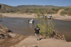
The Agua Fria river is running deep and wide. The river must be crossed to reach the trails that will be utilized in this event. Current level is about 30" to 3'. Crossing the river for those with 35's it should not be a problem. For those with smaller tires, and possibly no doors, it could be a problem. There are several threads on VJC, AZttora, and possibly others with pics of the river as recent as 3/20/10.

There is a possibility of more rain this week. With the warmer temps there is a possibility that snow run off will increase the level of the water.

BOD is building a contingency plan to have the event in Florence Junction and are working on obtaining an group ASTL permit for the group area on Cottonwood Rd. (Please see the official event thread for info needed ASAP).

There are many factors to consider and I do not want to limit comments, so I have not created the actual poll. Please post comments keeping the following suggestions in mind:

Hold event at TM no matter what
Move event to FJ
Make a decision based on water level as late as 4/4 or other date
etc.

Please post comments. Feel free to PM me if necessary.
I intend to make a trip to the river on the weekends of 3/28 and 4/3 to monitor the river level.

Thanks for your input.
 
Just to post this publicly as John and I have talked about already.
I believe we should obtain the permit for FJ and move the event now so people have time to plan. FJ is easier in and out and we dont really have to worry about the water levels. I want to do TM so bad but I think it would be Irresponsible of us to hold an event where the guys with smaller rigs cant make any of the runs because of the water levels.
I think we HAVE to keep in mind that this event is to invite and bring more people in and grow the chapter and relationships and not just cater to the people with massively built rigs. We can host runs at TM at ANYTIME throughout the year.
That being said I would like to put the paperwork in for the permit for FJ just in case. it will cost us 75 bux but I think its cheap insurance for our annual event.
Either way, we should make this decision relatively soon so people can make plans accordingly.

Brian
 
I PMd John earlier, I went out there Thursday and although the water was high it was still crossable in some areas, atleast for me and my 33s. I agree on getting the permit though i gave John my info he said he needed about 20 ppl?

Also with my experience of the Table Mesa area that river never stays high for long and with the temps we should be having im pretty confident itll be low enough by the 7th of april.

Sean.
 
Get permit just incase. But only move at last min if water is still to high. Waiting till last min is not a big deal and changing it from one place to another is not going to bug anyones plans. If there coming there coming and driving to FJ or Tm will not stop them.

TM or bust i say.....
 
Stay with TM. The easy/stock run can be run on the eastside of the I-17 to Sheeps Bridge. There are a couple semi harder (for stockers) trails there as well.
 
Keep it at TM... There is ways to get across and with caution Im sure everyone could make it. Plus I also believe with the heat that is coming by April, we should not worry about the levels being high.
 
crash cracker and i ran tm a few weeks ago. the river was easy to cross. although i am on 35s, the water level just barely got to the bottom of the axle tube. along the bank there are multiple areas to cross in the event one or more areas become washed out and/or rutted. in the area of the crossing the water was wide but not deep

KEEP IT AT TM you pansies!!!!!!!!!!!!!!!!!!!!!
 
Keep it at TM. The rivers have been up in the area because Northern AZ was warm this past week. Todays storm was a dud and did nothing. I think we will be fine, but it does not hurt to come up with just in case plan.
 
Plan for the alternate but hold off until the last minute to decide because if it does drop off with the water on the trails its gonna be hell(fun fun fun)...

themud
 
im down for whatever 31s or not. i havent had to be towed across or over anything yet i guess theres a first time for everything
 
I dont' think any one should be there with out a tow strap period. If they have to use it to cross the river, so be it.

If your not smart enough to kill the engine, tow across and not hydrolock your motor, not sure I want to be on the trail with you.

I'm not trying to be a smart ass, just stating the obvious. Our sport is about being prepared for whats out there.
 
I am looking forward to TM. Although, 75 bucks seems like a pretty cheap insurance plan in case we get some torrential rains/snow between now and then. I say get the permit just in case but keep it at TM. There is not much snow at all up here in Flag and I think the majority of the snowmelt is behind us. There is a tad more on the rim than we have here in Flag but I think by then it will be south of TM and in the lakes. It is supposed to stay warm for a while.

With that being said, we're up for wherever you decide to hold it but would prefer TM.
-G
 
^^^^^^^
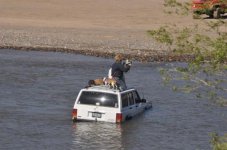
This was last weekend at the main crossing. The river jumped up to over 5' around the 13th/14th and took a bunch of people by surprise, even a group of rock buggies that got stuck out there. It's been falling since (about 8" in the last week) but is a tad below 3.5 ft still at the Rock Springs gauge. If it continues to fall, should not be an issue but agreed that we should have the permit for FJ in our back pocket.

Just to note as well, we should only be using the main crossing for Rockfest. There's been some chatter on various boards but the new owners of the property surrounding the crossing have posted no trespassing signs and are vigilinatly trying to enforce this. My understanding is they do not have any animosity toward rock crawlers at this point so we should make a good impresson to keep it that way. My understanding also is the main river crossing is the only legal easement across the property. Unless you go farther south around the bend, but I've heard that crossing is impassable at the moment. Hope to get a clearer picture of this in the next few weeks.
 
I mentioned to John that I was there last thursday the 18th and it wasnt as bad as that picture. Im going up Saturday though so Ill get some more pics. I still say TM all the way. half the adventure is pulling the pansies out right?
 
The pictures I posted were taken this past Sat during TTORA AZRocks 2010 at the main road crossing. It was apparent that they had not followed the "main" line across the river, but they weren't off the line that far. Getting submerged and having a rig fail in the water is not a "pansie" issue. (Just ask Mdub). It has to do with smart choices and rig capabilities.

I will be taking a look at the river and the access to the trails this weekend and next weekend also.

Based on the comments, we will continue with the planning to hold the event at TM. I will have official trail runs posted by Friday 3/25 with start times and min requirements.

At this time, the path to the entrance of DS and CD cross private property that has been posted. Trespassing across this property is not acceptable. The only means to run these trails is to start at the top of the trail and drive the trail "backward" and then drive it "forward".
 
i am available this weekend to run up there if somone needs an additional rig to go with them to check the area out.
 
Im planning a run at Florence the same camp location you guys used for last years rockfest, if you do change plans to Florence no big deal we can combine camp, if you dont mind all the toyota's.

http://wheelingarizona.com/forums/viewtopic.php?p=112002

I wont have my Cherokee back together till end of next month so I planned a trip with the FJ.
 
Status
Not open for further replies.
Back
Top