• Welcome to the new NAXJA Forum! If your password does not work, please use "Forgot your password?" link on the log-in page. Please feel free to reach out to [email protected] if we can provide any assistance.

JV Trails GPS Logs

GSequoia

Everyone says I'm a jerk.
NAXJA Member
Location
Torrance, CA
Switching to a new mapping program (DeLorme Topo) and I'd like to jack the JV trails into it. I've got Claw and Wreckig Ball but I need more.

Please share any GPS logs, plots, or maps that you have.

Thanks!
 
Anybody got something more detailed for the Clawhammer / Full of Hate / Misery Mile? I'd like to make sure I have it down right. I'm going off aerial photos, those maps, and the minimal GPS points listed there.

By the way - I'm not greedy, once I get this DB up I'll share it on my website!
 
Okay, to the JV experienced...


Does this look accurate?
Claw.jpg


I really wish I could color code roads in this software. But the cool part is I can route through the roads!
 
Yes, that looks accurate. Except that I've never driven Misery Mile, but that's my understanding of where it is.

You could also add in Boulderdash. Look on your map at the start of the word "Upper Big Johnson" and the "3250" mark on the contour line. The canyon that goes to the west (opposite the out of Big Johnson) is Boulderdash. Basically, when running up Upper Big if you turn right in that canyon you exit down the sandhill to the backside, if you turn left in that canyon you go down Boulderdash.
 
BTW, do you have Spooner on your map?
 
Ugh why are you using Delorme?

I've got the gpx file from KOH '09. Want that?
 
Ugh why are you using Delorme?

Because I have it. I kinda like National Geographic Topo better but they are changing focus to Internet based and it gets kinda spendy at $75 - $90 per state/region.

I've got the gpx file from KOH '09. Want that?

Yes I do. gsequoia *at* mac *dot* com
 
Because I have it. I kinda like National Geographic Topo better but they are changing focus to Internet based and it gets kinda spendy at $75 - $90 per state/region.


Yes I do. gsequoia *at* mac *dot* com

sent
 
Spooner is the only other main canyon in the ridge, next to Outer Limits. It should be easy to see on the topo NW of Outer Limits, the bottom is close to OL but the canyon angles up the other direction in the ridgeline.
 
Okay I've got the bulk of my JV mapping project done. I still have to hash out the details on how I'm going to put this on my website but here are the trails I have. Let me know if anything important is missing, I based this off of the Extreme Wheelers 4 Christ maps and the KOH track file.

Spooners Canyon
Outer Limits
Aftershock
Highway 20
Sunbonnet
East of Sunbonnet (Made that name up, off the KOH tracks)
Fissure Mountain
Sledgehammer
Jackhammer
Jackhammer North
Bender Alley
Wrecking Ball
Clawhammer
Full of Hate
Misery Mile
Gatekeeper
Lower Big Johnson
Upper Big Johnson
Boulderdash
Tackhammer
Full of Love
Backdoor
Resolution

I also included what I'm calling:
KOH South East Loop (the track that dipped south of the Hammers range, brushed up against the USMC land, then circled back to Aftershock)
KOH West Loop (The long "finger" that juts North West from the South end of Means Lake back to the start of Backdoor)
Northern Loop (Another KOH loop that was about a 5 mile looped "bubble" off of the northern road in the area, that nortern road is the one that meanders over to Emerson)

That's it, I have some questions in the next post (Didn't want to lose them in this one).
 
Now for the questions.


Spooners Canyon: I wasn't able to tell from my aerials but do you get to the East side of the canyon off of the little road that leads to Blue Ribbon mine?

Chocolate Thunder: I was unable to find this from above. Anybody got a GPS plot of it (or even just a waypoint at the start so I can locate it's canyon)?

Yes, you folow the road around behind the mine.


I have chocolate thunder in my GPS. I'll get you the start waypoint tonight, if nobody chimes in first.
 
If you look at Google Earth, or should be able to see it on the topo, there are only two big canyons in middle of that long ridge, the one to the south is OL, the one slightly to the north of OL is Spooner. The bottms of both canyons are close to each other, and yes the road to the mine takes you to the bottom of Spooner.

The track east of Sunbonnet is a trail called Hell's Gate. We run those two trails together as one trail, up Hell's Gate to the top of the saddle, then down Devil's Slide to the bottom of Sunbonnet.

Highway 20 is actually called Highway 19, 20, 21.


Nice that you put the KOH tracks on there, but it would be hard to follow unless you had the track in your GPS.


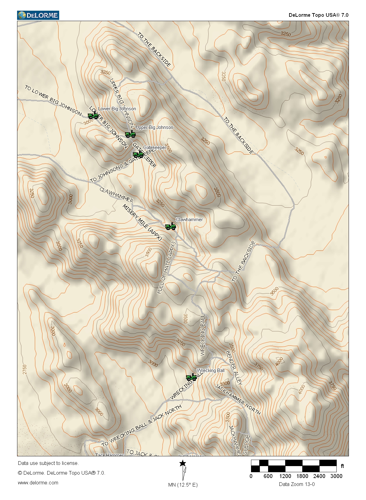
Oh, and Chocolate Thunder is the next larger canyon to the north of Tackhammer, in the same ridgeline.
 
Back
Top